Monday 11 December 2017 La Chamoniarde, the local mountain security association posted on its Facebook page the first estimation of avalanche risk of the season!
HIGH RISK OF AVALANCHE!!!
Estimation risk until Tuesday 12th December 2017 in the evening.
Below, the photo with the general map and the full report for the Mont Blanc Massif.
Meteo-France in Lyon has issued on 11th December 2017, at 4pm, an weather alert to avalanches:
Snow accumulation above 1700/2000m. The rain has risen to 2200, locally 2400m, causing substantial purges. The current snowfall adheres quite well, but large spontaneous avalanches are still possible on steep unpurged slopes.
High-mountain: probable big avalanche with aerosol in the fog and strong wind.
Avalanches triggered by skiers / hikers:
The wind blew hard, from W then Foehn to SW. Snow accumulations formed in various exposures. A hiker can easily trigger 2 types of plaques:
1) Wind slabs in deposit zones.
2) Friable plaques of recent snow on old brittle underlay. The risk increases above 2200m.
To check out the full report, click here
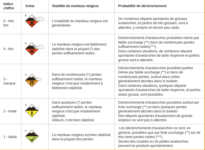
Check out the new signage
ANENA (Association Nationale pour l’Étude de la Neige et des Avalanches)
Avalanche Danger Scale and new pictograms: www.anena.org/8912-echelle-de-risque-d-avalanche-et-nouveaux-pictogrammes.htm
Check the flags flying in the Chamonix ski resort, they must be the old ones. More info about Avalanche warning flags.


